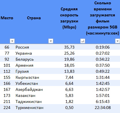
Средняя скорость доступа в интернет в регионе СНГ составляла 22,92 Мбит/с. В тройку самых быстрых стран этого региона входят Россия (57,95 Мбит/с, 62-е место), Украина (38,13 Мбит/с, 101-е место, скорость которой значительно снизилась в этом году по понятным причинам) и Беларусь (34,10 Мбит/с, 109-е место). Самыми медленными странами региона были Таджикистан (2,98Мбит/с, 214-е место), Туркменистан (4,49Мбит/с, 206-е место) и Азербайджан (10,20 Мбит/с, 171-е место). И Таджикистан, и Туркменистан вошли в число 20 самых медленных стран мира.
60 тысяч таджикских мигрантов уехали из России в Таджикистан в 1 квартале 2022 года по данным Международной Организации по Миграции (МОМ).
В России работает порядка четырех миллионов мигрантов из Центральной Азии: миллион – из Таджикистана, столько же – из Кыргызстана, примерно два миллиона – из Узбекистана и 200 000 – из Казахстана. Они работают, в основном, в строительстве, в транспортном секторе, в сельском хозяйстве и в сфере услуг, а также в некоторых областях, требующих более высокой квалификации.
Денежные переводы мигрантов, работающих в России, составляли до 30 процентов ВВП стран Центральной Азии. Сегодня многие из них возвращаются домой, а объемы переводов от тех, кто остался, стремительно сокращаются.
Как сообщают из МОМ, санкции, введенные против России в качестве ответной меры после нападения на Украину, тяжелейшим образом могут сказаться на российской экономике и на рынке труда. Речь может идти о потере порядка двух миллионов рабочих мест и росте безработицы с 4,4 процента до 7,8 процента. А спад экономики России неизбежно повлияет на доходы работающих там мигрантов и, соответственно, на экономическую ситуацию в их родных странах.
«Резкое сокращение переводов из России несомненно негативно скажется на экономике стран, полагающихся на денежные переводы, – отмечает Ренате Хельд, Директор регионального отделения МОМ в Вене. – Большинство мигрантов выразили желание пока остаться в Российской Федерации, но если в экономике произойдет поворот к худшему, все больше людей будет возвращаться домой».
И это уже происходит. По данным МОМ, в первом квартале нынешнего года из России на родину уехали 60 000 мигрантов из Таджикистана и 133 000 – из Узбекистана. Теперь они, скорее всего, пополнят армию безработных в собственных странах.
Чтобы понять масштабы проблемы, достаточно взглянуть на цифры: в 2020 году, например, денежные переводы трудовых мигрантов в Кыргызстан и Таджикистан составили, соответственно, 31 процент и 27 процентов ВВП каждой из этих стран. И подавляющее большинство переводов приходило из России. Общая история, географическая близость, знание языка, облегченные административные процедуры – все эти факторы придавали России особую привлекательность в глазах трудовых мигрантов из Центральной Азии.
Как меняется ситуация сегодня? По прогнозам Всемирного банка, объемы денежных переводов из России в этом году резко сократятся: в Казахстан – на 17 процентов, в Узбекистан – на 21 процент, в Таджикистан – на 22 процента и в Кыргызстан – на 33 процента.
За этими цифрами – угроза обнищания множества семей. Денежные переводы, которые посылали своим близким мигранты – как правило, люди из бедных семей, зачастую сельские жители, – помогали тем выбираться из бедности. Например, в Кыргызстане в 2019 году благодаря денежным переводам уровень бедности сократился с 31,2 процента до 20,1 процента. Сегодня же Всемирный банк предрекает тому же Кыргызстану рост уровня бедности до 38 процентов.
Правда, отмечают в МОМ, прогнозы могут и меняться. Скажем, объемы денежных переводов в Кыргызстан в марте этого года по сравнению с мартом прошлого предсказуемо сократились на 28 процентов. В то же время в апреле мигранты из Узбекистана отправили на родину рекордную сумму – 1,07 млрд долларов, что почти в два раза больше, чем год назад. Тем не менее, Центробанк Узбекистана предсказывает сокращение переводов на 18-25 процентов.
В МОМ настаивают на необходимости регулярно отслеживать потоки мигрантов и денежных переводов и поддержать вернувшихся мигрантов и их близких.
Уровень алкоголизма в Таджикистане довольно низок по сравнению с большинством стран в мире. Таджикистан занимает лишь 102 место (2,57%) среди мужчин и 92 место (0,29%) среди женщин по количеству зависимых от алкоголя.
Среди стран Центральной Азии по количеству зависимых от алкоголя лидирует Казахстан — 11 место (9,52%) среди мужчин. С женщинами ситуация ненамного лучше — 19 место (1,48%) из 182 стран мира.
Уровень алкоголизма в Кыргызстане выше чем у соседей – Таджикистана и Узбекистана. Кыргызстан по количеству зависимых от алкоголя занимает 98 место (2,71%) среди мужчин и 89 место (0,30%) среди женщин.
Узбекистан — 110 место (2,10%) среди мужчин и 101 место (0,23%) среди женщин.
Образцом для стран Центральной Азии является Туркменистан — 130 место (1,51%) среди мужчин и 115 место (0,17%) среди женщин.
Возглавляют мужской рейтинг по количеству зависимых от алкоголя — россияне, венгры и литовцы, среди женщин — австралийки, россиянки и колумбийки.
По данным МВД РФ, среди стран, граждане которых больше всего получили российские паспорта, Таджикистан был на втором месте – после Украины. Так, только в прошлом 2021 году российский паспорт получили более чем 103 тысячи таджиков. А за последние пять лет гражданством РФ обзавелись порядка 300 тысяч уроженцев Таджикистана.
Подавляющему большинству таджиков российское гражданство было нужно для решения бюрократических вопросов и чтобы не платить за оформление документов на работу в России. Переезжать на постоянное место жительства в Россию, а тем более вывозить в Россию свои семьи многие таджики не торопились.
По данным Центрального Банка Российской Федерации физлица перевели из России в Таджикистан $1,3 млрд за три квартала 2021 года. Такая информация содержится в базе данных Центрального банка России.
Переводы в 1 квартале 2021 года составили — $329 млн, во втором — $426 млн, в третьем — $534 млн.
Средняя сумма перевода выросла со $126 в первом квартале 2021 года до $154 в третьем квартале 2021 года.
Переводы в Таджикистан по сравнению с 3 кварталами 2020 года снизились на 0,5% или на $6 млн.
Переводы физлиц из России в Таджикистан (в миллион долларов США)
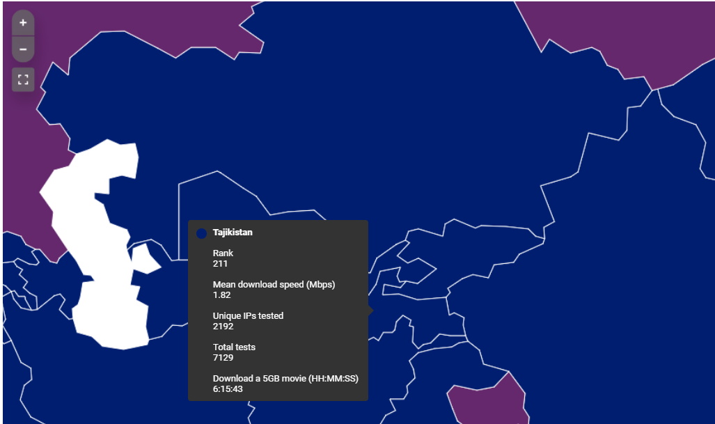
Ресурс Cable.co.uk проанализировал результаты миллиардов тестов скорости интернет-подключения в 224 регионах мира (ряд удаленных островных регионов некоторых стран, например, Великобритании, рассмотрены отдельно).
Исследование посвящено именно широкополосному доступу в Интернет (ШПД). Широкополосный или высокоскоростной доступ в Интернет – доступ в Интернет со скоростью передачи данных, превышающей максимально возможную при использовании коммутируемого доступа с использованием модема и телефонной сети общего пользования. Осуществляется с использованием проводных, оптоволоконных и беспроводных линий связи различных типов. Выделяют мобильный широкополосный доступ (мобильный ШПД) и фиксированный широкополосный доступ. Фиксированный ШПД строится на основе проводных соединений, в то время как мобильный ШПД включает в себя передачу данных по беспроводным соединениям.
Мобильный ШПД в настоящее время использует технологии мобильной связи WCDMA/HSPA (поколение 3.5G), HSPA+ (поколение 3.75G). Также применяются технологии 4G: WiMax и LTE.
В список 10 стран с самой высокой скоростью широкополосного доступа в мире входят 8 стран Западной Европы. Лидер этого рейтинга имеет среднюю скорость подключения 274,27 Мбит/с. Такая скорость зафиксирована на острове Джерси, расположенном в проливе Ла-Манш. Джерси стал первым регионом в мире, где оптоволоконное подключение доступно в каждом домохозяйстве. Второе место занял Лихтенштейн, следом идут Исландия и Андорра.
В десятку лидеров вошли всего два региона за пределами Западной Европы: Макао (128,56 Мбит/с) и Венгрия (104,07 Мбит/с). Средняя скорость подключения в Великобритании составляет 51,48 Мбит/с – эта страна занимает 20-е место в Европе и 43-е место в мире. Соединённые Штаты занимают 14-е место в мире со средней скоростью 92,42 Мбит/с.
Широкополосный доступ в Интернет в Таджикистане позволяет подключение со средней скоростью 1,82 Мбит/с. Таджикистан занимает 211 место из 224 регионов (стран и островных территорий ряда стран).
Среди бывших стран СССР (кроме балтийских стран) наилучшие показатели у Российской Федерации – 66 место в рейтинге, средняя скорость подключения – 35,73 Мбит/с. Страной с самой низкой средней скоростью подключения в мире является Туркменистан (0,50 Мбит/с) – 224 место в рейтинге.
247 тысяч таджикских нелегальных мигрантов в России
Замминистра внутренних дел России Александр Горовой в своем выступлении на пленарном заседании Межпарламентской ассамблеи СНГ обратился к парламентариям с просьбой усилить разъяснительную работу среди своих соотечественников по поводу соблюдения миграционного законодательства.
Он напомнил про то, что указ президента России «О временных мерах по урегулированию правового положения иностранных граждан и лиц без гражданства в РФ в связи с угрозой дальнейшего распространения новой коронавирусной инфекции (COVID-19)» действует до 15 июня.
В соответствии с этим документом, иностранцам, находящимся в России нелегально, была предоставлена возможность урегулировать свое правовое положение без применения санкций со стороны правоохранительных органов.
Силовик привел статистику МВД, согласно которой сегодня в России находятся более 332 тысяч нелегальных мигрантов из Узбекистана, 247 тысяч — из Таджикистана, 152 тысячи — с Украины, 120 тысяч — из Азербайджана, 115 тысяч — из Киргизии, 61 тысяча — из Армении, 56 тысяч — из Молдавии, 49 тысяч — из Казахстана.
146,6 тысяч таджиков – это число зарегистрированных, а сколько ещё без регистрации?
В Москве сейчас чуть меньше 800 тысяч иностранцев, год назад их было свыше миллиона; в основном это граждане Кыргызстана, Узбекистана и Таджикистана. Об этом сообщает РИА Новости со ссылкой на начальника управления по вопросам миграции столичного ГУМВД Дмитрия Сергиенко.
«Количество иностранных граждан, находящихся в Москве, сократилось на 21%, составляет 789 тысяч. На тот же период прошлого года их было более миллиона», – сказал Сергиенко на заседании комиссии по безопасности, миграционной политике и межнациональным отношениям в Общественной палате Москвы, уточнив, что большинство из них прибыли в Россию в порядке, не требующем получения визы (почти 93%).
«В абсолютных показателях 733 тысячи из них, большую часть, составили: граждане Кыргызстана – 30%, Узбекистана – 27%, Таджикистана – 20%», – добавил он.
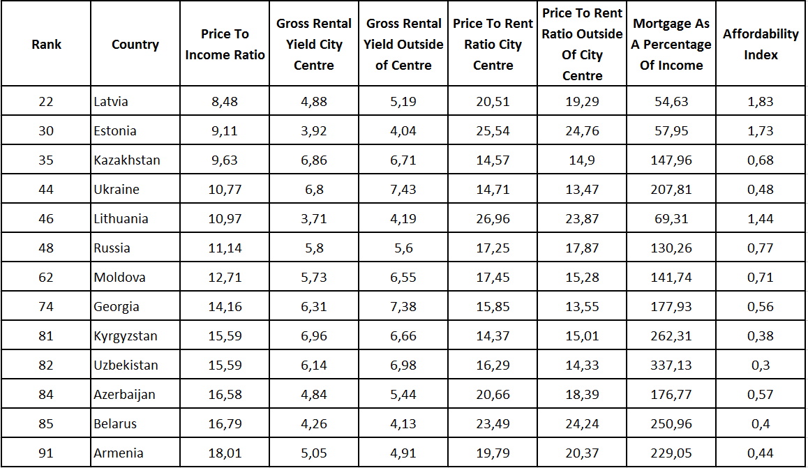
Рейтинг соотношения цен на жилье и среднегодового дохода семьи
Глобальная база статистических данных Numbeo опубликовала рейтинг 109 стран по соотношению средних цен на жилье и среднего годового дохода семьи. Данных по Туркменистану и Таджикистану аналитики сербского сайта собрать не смогли.
Данная информация демонстрирует, за сколько лет семья сможет накопить на квартиру, если будет откладывать полторы средние заработные платы в месяц. При этом заработная плата мужчины учитывается полностью, а женщины – только половина. На годовой доход семьи делилась средняя стоимость квартиры площадью 90 квадратных метров.
Очень любопытный рейтинг получился, где рядом с развитой страной – страна с развивающейся экономикой, и в вверху рейтинга и в самом его подвале.
Согласно рейтингу лучше всех – в Саудовской Аравии, Пуэрто-Рико, ЮАР, США и Палестине(!!!).
А вот хуже всех картина – в Сирии, Гонконге(!!!), Ямайке, Камбодже, Шри Ланке, Иране, Филиппинах и Китае(!!!).
Страны бывшего СССР – как в топе рейтинга, так и ближе к “подвалу”, но не худшие. Хотя данных по Таджикистану нет, можно с большой долей вероятности предположить позицию рядом с соседями в Центральной Азии – Узбекистаном и Кыргызстаном.
Источник данных: https://www.numbeo.com/property…/rankings_by_country.jsp


")